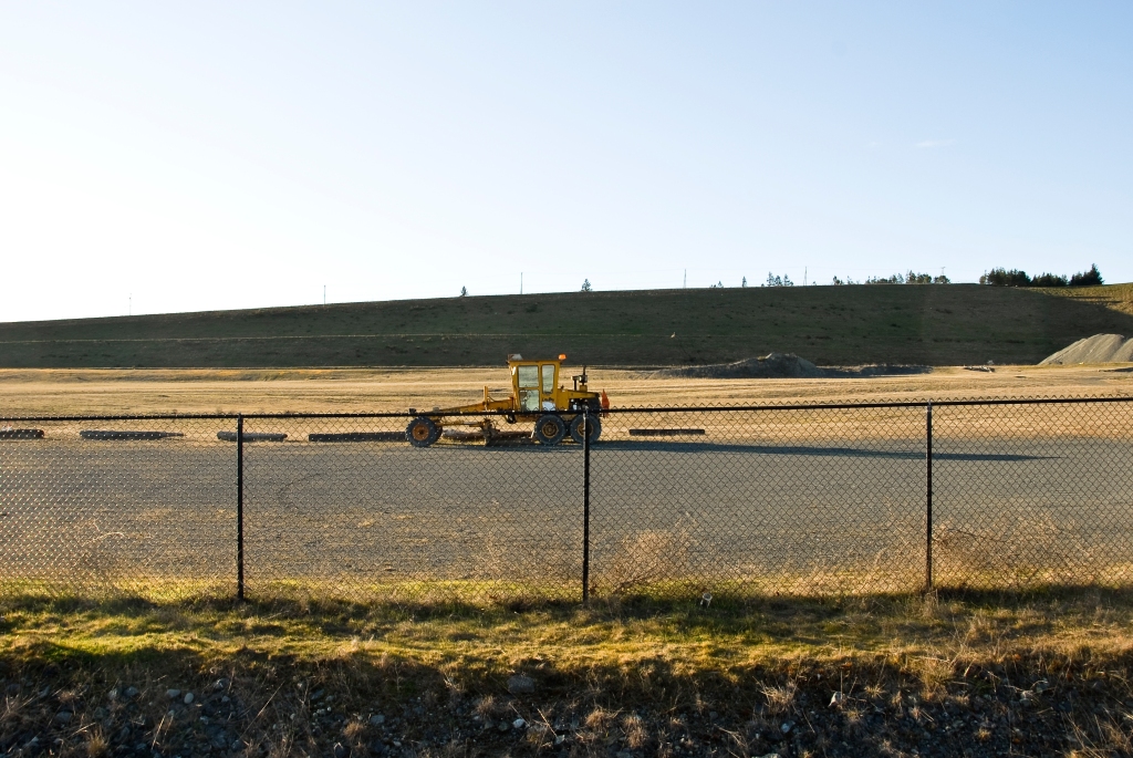
What Changed? Tillicum Road and the Remaking of Saanich’s Streets
By Joshua van Es
Oct 12, 2026
—————————————————————————————————
In 2005, a Saanich report concluded that Tillicum and Burnside Roads should not be reduced to a single lane in each direction.
Saanich was working to expand its cycling network, but engineers modelled that reducing Tillicum to one lane each way would cause traffic to stack up, block access from residential side streets and force vehicles to weave, while raising concerns about emissions and safety during peak hours. Council endorsed the report.
Seventeen years later, Saanich did what the earlier report had advised against. In 2022, Tillicum Road was reduced to a single general-purpose lane in each direction to install protected bike lanes.
What changed?
Not the underlying engineering concerns. That year, Saanich still warned that drivers “may see increased traffic delays during peak hours.” Recommendations before Council acknowledged that the changes “could have a negative impact on traffic / transit operations along the corridor, and potentially traffic volumes on nearby streets.”
What had changed were the people sitting around the Council table.
In 2020, Dean Murdock, a former Saanich councillor who would be elected mayor two years later, saw the issue very differently:
“It’s just not the case that you’re going to add further congestion by reducing those vehicle lanes in favour of creating those cycling lanes.”
How could someone, faced with essentially the same engineering concerns, come to such a different conclusion?
The answer is larger than one mayor or one Council.
Over those seventeen years, several disparate currents of thought had begun to converge.
Climate policy increasingly sought to reduce the number of kilometres travelled by car. Active-transportation policy sought to move more trips to walking, cycling and transit. Urbanists challenged car dependence and the amount of public space devoted to automobiles, often looking to European cities as models for a different way of organizing urban life. Vision Zero and the Safe System approach began from a different premise: that deaths and serious injuries should be prevented by designing roads around the inevitability of human error.
Other ideas joined them. Equity advocates questioned whether streets built primarily around motorists fairly served people who could not or did not drive. Some critics went further, connecting automobile dependence to consumer culture, industrial capitalism and the political power of the industries built around it. Still others challenged the North American model of low-density, car-oriented suburban development itself.
These ideas came from different places and pursued different ends. They were not universally accepted, nor did they amount to a single coherent philosophy. Yet increasingly, they shared a criticism of the place the automobile had come to occupy in modern society.
These ideas began to find their way into the political sphere. In the process, the automobile itself acquired a significance beyond transportation. For some, it represented personal freedom, convenience and independence. For others, it now symbolized pollution, inequality, suburban sprawl and an outdated approach to urban life.
The disagreement had become about far more than traffic. Arguments about climate, density, public space, personal freedom, consumerism and the proper role of government were increasingly finding expression at the municipal level through decisions about city streets.
One expression of these ideas was the concept of the Complete Street. A road that had long performed its intended functions—moving cars and buses, with sidewalks for pedestrians—could now be regarded as incomplete. The street itself had become a canvas on which these broader ambitions competed for space. Its design increasingly reflected not only how people moved, but ideas about how communities should function.
By the 2020s, many of these ideas were embedded in Saanich’s own transportation policies.
The municipality’s Uptown–Douglas Plan acknowledged the shift explicitly: “Saanich has committed to creating a mobility network that embraces different priorities than existed when the current street network was developed.”
The Active Transportation Plan seeks to “reduce car dependence,” improve health, strengthen community connections and incorporate equity into transportation planning. The Official Community Plan calls for reducing total vehicle kilometres travelled. Vision Zero and the Safe System approach became part of Saanich’s road-safety framework. And in 2025, Saanich adopted a Traffic Calming Policy stating that road design can be modified to “compel drivers to travel in ways that are appropriate for the surrounding context.”
The extent of this transformation is difficult to appreciate by looking at any one project in isolation. These policies are only part of a broader planning framework. Saanich also has a Speed Limit Establishment Policy and a Neighbourhood Bikeways program, alongside neighbourhood plans, corridor plans, capital works programs and individual road improvement projects.
These undertakings do not operate independently. They frequently refer to one another, share objectives and apply to the same streets.
On the ground, this overlapping framework often means protected bike lanes, lane reductions, lower speed limits, speed humps and raised crossings, curb extensions and traffic bulbs, chicanes, traffic circles, diverters, protected intersections, narrowed travel lanes and restrictions on left and right turns. With them come more signs, pavement markings, concrete barriers and plastic bollards.
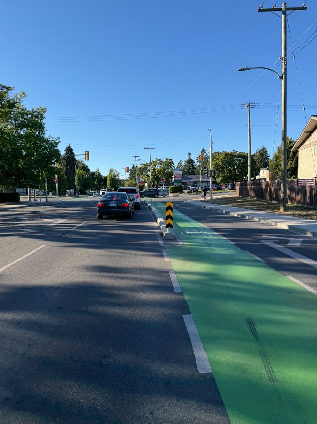
A highly unusual and non-intuitive road design which places concrete
curbs in between lanes travelling in the same direction, at Shelbourne and Feltham.
Collectively, these interventions are changing the physical character of Saanich. Streets that were once relatively open, simple and unobtrusive are becoming more intensively engineered and visually urban, with our movement increasingly divided, channelled and prescribed.
Longtime Saanich resident June Dittmer recently described the change this way:
“I look at our roads and I see a frustrated plan running on auto pilot. Years ago, when my family lived on Gorge Road, a simple painted lane on each side beautifully balanced the needs of cars, buses, and bikes. It worked. Today, I see our streets systematically squeezed into narrow concrete chutes. The constant whiplash of speed limits bouncing between 30 and 50 km/h, paired with endless signage, leaves me with driver fatigue rather than a sense of safety. Squeezing roads with no escape path for everyday human error, I worry about our first responders being physically hemmed in when seconds count.”
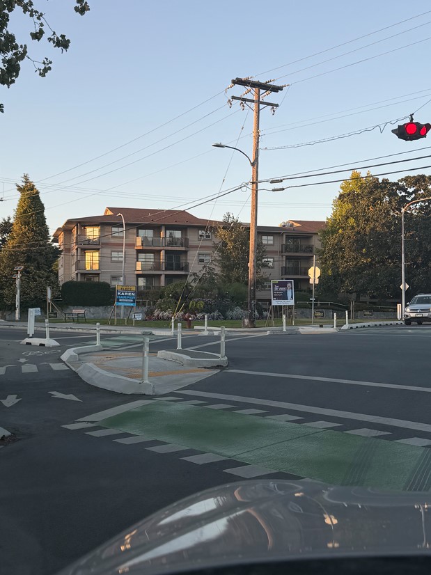
Multiple concrete islands, curbs, and bollards at this intersection highlight Saanich’s new approach to road safety.
Beyond their impact on the physical landscape, implementing these plans and programs also requires substantial financial commitments. Saanich’s Road Safety Action Plan anticipates approximately $21 million in spending over ten years. Its capital plan provides approximately $45.5 million for Complete Streets between 2026 and 2030. The next phase of work on Gorge and Tillicum has a project budget of approximately $15 million.
The recently completed Shelbourne Street Improvements Project cost $72.3 million across three phases, including substantial underground infrastructure replacement alongside cycling facilities, sidewalks and other transportation improvements.
And preliminary estimates presented to Council in February 2025 placed the cost of short- and medium-term Active Transportation Plan projects at approximately $252 million. These figures overlap, making it difficult to determine the total financial commitment simply by adding the individual plans and project budgets together.
But it is the streets themselves that give us a clearer picture of the scale of this ambition.
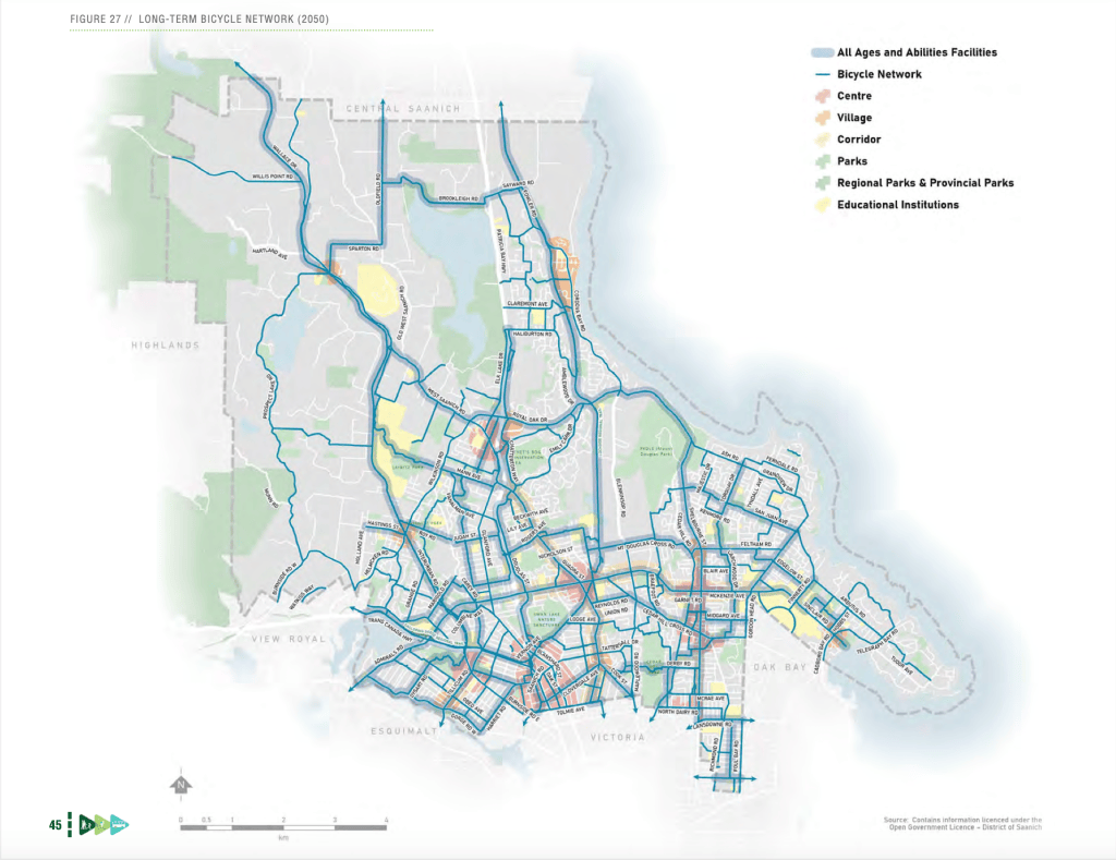
The above map includes the roads planned for AAA protected bike lanes in blue
highlighter. The Neighbourhood Bikeways project will include hundreds of additional roads that aren’t identified in this map.
Across roughly twenty Saanich plans and programs, cross-referenced against the municipality’s own road classifications, 98 of Saanich’s 107 Major and Collector roads are slated for physical infrastructure changes within this overlapping transportation-planning framework.
That’s approximately 92 per cent of Saanich’s major and collector roads, representing roughly 97 per cent of their combined length.
And its reach extends well beyond the busiest urban corridors. Approximately 165 streets are designated for Saanich’s Neighbourhood Bikeways program, with roughly 100 slated for implementation over the next five years. The bikeways can include speed humps, traffic circles and other traffic-calming measures. The network reaches even into Saanich’s rural landscape, including roads such as Beaver Lake Road, bringing a more engineered and urban form of street design into places valued precisely for their natural, relatively untouched character.
A transformation of this sheer scale rarely occurs without a strong vision of what a place ought to become.
But a vision of a better community is not the same thing as a plan suited to every community. Places have their own geography, history, culture, patterns of development and ways of life shaped over generations. Ideas travel easily. The conditions that determine their success do not.
Saanich is not Amsterdam. In the Netherlands, more than two-thirds of all trips are shorter than 7.5 kilometres, and the average conventional bicycle trip is just over three kilometres. For many Dutch people, cycling is less a statement of values than a practical response to the places in which they live: largely flat, compact communities where everyday destinations are often close by. None of that is created by a cycling network.
Saanich differs from Amsterdam in its density, distances, terrain, zoning, built form and transportation alternatives.
But there is another reason for caution. Planning orthodoxies change. The car-oriented suburb that many planners now seek to move beyond was itself, two generations ago, part of planning’s vision of the future. Today’s prevailing ideas may prove no more permanent, yet they are being given physical form that may endure for generations.
For those reasons, a transformation of this scale should carry a correspondingly high burden of justification. Its necessity should be clearly demonstrated, its benefits measured, and its costs and trade-offs properly understood.
The starting point matters. Saanich begins from a very different safety baseline. A traffic-safety study commissioned by the Capital Regional District recorded 41 road fatalities across the region’s municipalities between 2017 and 2021, an average of approximately two deaths per 100,000 residents annually. That is lower even than the approximately four per 100,000 recorded in the Netherlands in 2024 and 2025.
Saanich’s own Road Safety Action Plan also reports an overall crash rate approximately 30 per cent lower per capita than comparable communities.
And if the case for transformation rests on what these changes will achieve, their results matter just as much as the baseline from which we begin. Saanich’s transportation policies seek fewer serious collisions, less automobile dependence, more trips by walking, cycling and transit, and fewer kilometres travelled by car. Those are outcomes that can be measured.
Tillicum could provide a useful test. Four years after the lane reductions, however, we have found no comprehensive published before-and-after evaluation of travel times, transit reliability, nearby traffic, collisions or cycling volumes.
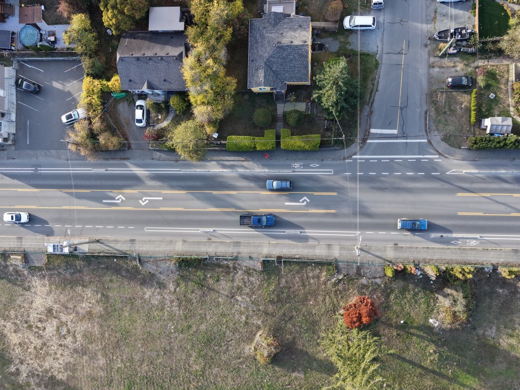
Part of Tillicum road that had lane reductions.
But whether these projects are needed, or even achieve their stated objectives, is only half the equation.
The political philosopher Michael Oakeshott once observed that “innovation entails certain loss and possible gain.”
A road can become safer while becoming substantially slower. A cycling route can attract more riders while making transit less reliable. Traffic can disappear from one street by appearing on another. A lower speed limit can reduce the severity of a collision while adding time to thousands of journeys. A protected intersection can reduce one kind of risk while making the street more complex to navigate. Money committed to one intervention is money unavailable for other priorities.
One of the frameworks behind this transformation states its governing principle unusually plainly. The architects of Sweden’s Vision Zero approach wrote that “life and health can never be exchanged for other benefits within the society.” Its concern is specifically death and serious injury, rather than every collision. But within that boundary, the principle does not simply put safety first. It holds that safety cannot be traded against other benefits at all.
Yet a road is not designed only to prevent collisions. It also exists to move people. Mobility is itself a public good. So are reliable transit, emergency access, the movement of goods and services, and the ability of people to reach work, schools, shops and one another in a municipality where many journeys cannot realistically be made without a car.
At a certain point, it becomes fair to ask why major roads in a region of nearly half a million people are being reduced, or proposed for reduction, to the same number of general-purpose lanes as the main streets of countless small towns and villages across the continent.
There are less quantifiable things at stake as well. Simplicity has value. So does the ability to move through a familiar street without navigating an accumulation of barriers, signs, markings and restrictions. And the physical character of a place matters too, perhaps more than these discussions often acknowledge. A municipality can become safer or more efficient by one measure while becoming less pleasant, less convenient or less recognizably itself.
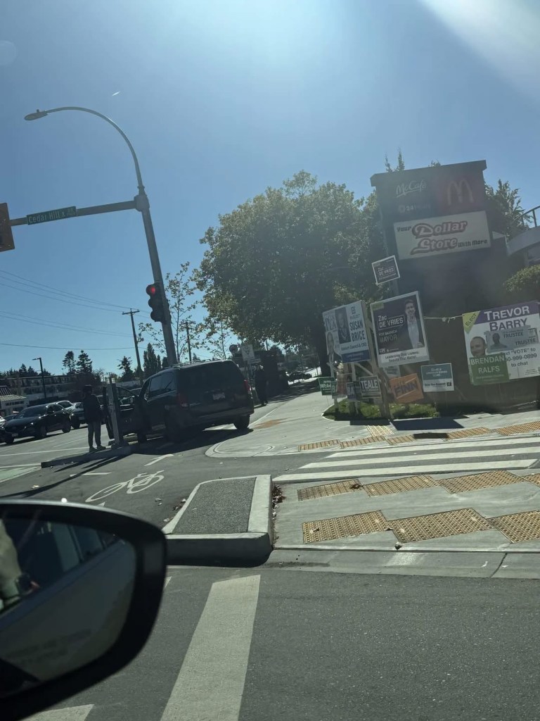
A accident in which a motorist drove over the new physical infrastructure
meant to improve safety on Shelbourne. The car has come to rest on the new lowered
waiting areas for pedestrians, which positions them at a lower level than traditional
raised sidewalks, hurting sight-lines and potentially making collisions between
pedestrians and vehicles more serious.
There is also a case that simplicity can make streets safer. Hans Monderman, the Dutch traffic engineer and pioneer of the “shared space” approach to road design, believed that the accumulation of rules, signs and instructions could make people less attentive and less responsible for their own behaviour.
“The greater the number of prescriptions, the more people’s sense of personal responsibility dwindles.”
He had a blunter way of putting it:
“When you treat people like idiots, they’ll behave like idiots.”
Increasingly, we are seeing something like that unfold on Saanich’s streets. As roads that once allowed relatively simple and intuitive movement become more constrained and prescriptive, we are also seeing changes in how some people drive. Drivers tailgate through speed limits lowered in pursuit of Vision Zero. On Shelbourne, some accelerate when a second lane briefly opens, trying to get ahead before traffic returns to a single lane. At the redesigned Maplewood intersection, drivers cross from the far-left lane to make a right turn. Elsewhere, drivers manoeuvre around barriers intended to prevent particular turns or movements.
These are different behaviours, but they arise in the same kind of environment: one that increasingly funnels, restricts and directs movement where it once simply allowed it. In places, the intervention itself has created a problem that did not exist before: a merge where traffic once flowed, a turn that now requires a detour, a lane that ends where it used to continue.
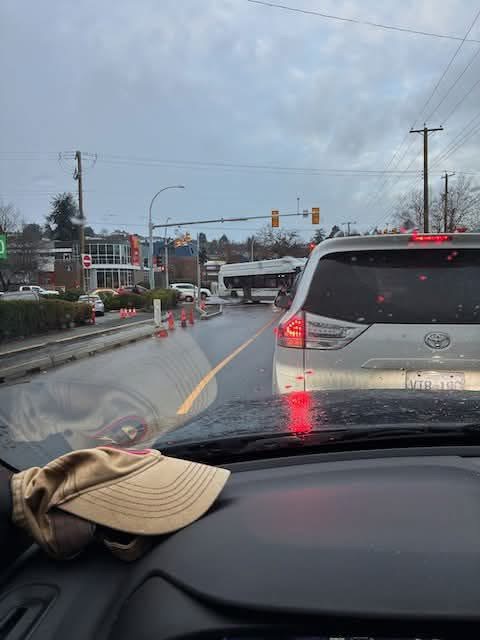
A BC Transit bus has difficulty making the turn at the new intersection from
Shelbourne onto Cedar Hill X, due to curb design.
All of which raises a more basic question about where planning should begin: with an idea of what a place ought to become, or with the place itself? How do people actually live here? How do they get to work, take their children to school, buy groceries, visit friends and move through their community? Where are the genuine problems? What changes would make things work better?
People can sense the difference. They know when a street is being changed to solve a problem they experience, and when it is being changed in the hope that they will change with it.
The objections to these changes are often not to any individual bike lane, speed hump, bollard or reduced lane. They are to what people understand those things to represent: a gradual remaking of the streets around a vision of how they ought to live and move. A vision they may not share.
Which leaves perhaps the most important question: are these the changes that the people who live in Saanich actually want?
Saanich is not a blank canvas for the aspirations of urban planners. It is an established community—its neighbourhoods and streets already woven into people’s lives. There is a difference between adapting our ideas to the place and the people who live here, and reshaping the place and the lives lived within it to fit those ideas.
Good planning requires a certain humility. Sometimes a road is already doing its job. Sometimes the benefits of an intervention are not worth what it takes away. Sometimes the way people actually choose to move through their community deserves more weight than the way a plan would prefer them to move.
The question should not simply be, “Can we make this change?” It should be, “Should we?”
Twenty-one years ago, Saanich’s report on Tillicum and Burnside reached a remarkably simple conclusion:
“As a result, this option was not supported.”
Perhaps we should return to a kind of planning that knows not only how to change a place, but also when to leave it alone.
—————————————————————————————————
Sources:
Traffic mortality down by 42 percent in past 25 years | CBS.nl
Tillicum – Burnside Action Plan (2005)
Saanich, new protected cycling lanes coming to Tillicum Road (2022)
Saanich, Tillicum Road protected bike lanes
Active Transportation Plan 2024
Traffic Calming Policy (adopted)
RSAP adoption release (Oct 2024)
Uptown–Douglas draft, Section 6
2026 Combined Capital Works Book
Shelbourne completion release (2026)
Class D ATP estimates (Izard repost)
Bikeways What We Heard, spring 2026
Monderman, Der Spiegel 2006 (Planetizen repost)
https://www.crd.ca/media/file/2023-04-11tscminutes?utm_source=chatgpt.com
https://www.cbs.nl/en-gb/news/2026/15/more-road-traffic-deaths-in-2025
————————————————————————————————
See also:
Index of Articles and other material About ‘Active Transportation’ Planning – CRD Watch Homepage
Index of articles regarding proposed plans for Quadra/McKenzie and transit-enabled development upzoning. – CRD Watch Homepage


Leave a Reply