Letter by Mei Ang to Saanich Council Regarding the Shelbourne Valley Plan Update.
Mei Ang
Feb 27, 2026
Hello, I am a long-time resident in the Shelbourne Valley. I want to share with you a letter I wrote to Saanich Council concerning the Shelbourne Valley Plan Update that went before Council for deliberation on 24 February 2026. I would like to make an addendum to Section: Issues Raised In Staff Report, Item D from “I strongly oppose” to “I strongly oppose 12 and 18 storeys”.
Dear Mayor and Council,
Shelbourne Valley Plan Update – Council Meeting on 24 Feb 2026
My apologies for this rather long letter. I have decided to spend some time writing it because I think there is a need to share my interpretation of how the mostly buried wetlands and creek in the Shelbourne Valley Centre area work. I hope you will take the time to read it as it may help in your decision-making. I have some knowledge of hydrology as I did research on the ethnoecology of a very complex equatorial river.
Issues Raised In Staff Report
- Feltham Boundary – with the splitting of the SVP into three separate parts, has any thought been given to absorbing the dangling Feltham section into the Gordon Head Plan? This is a more organic arrangement as Feltham is a part of the Gordon Head community. In addition, by geographical definition, the Shelbourne Valley is the watershed of the Bowker Creek whereas the Feltham area lies within the Douglas Creek watershed. The SVP appears to be focused exclusively on Bowker Creek. The SVP was originally conceived as the Shelbourne Corridor Action Plan – a plan that envisioned the whole Shelbourne Street as a transportation corridor. This is no more as the corridor has now been broken into three parts. It is a good time to do some housekeeping.
- Designation for 1514/1520/1538 Cedar Hill Cross Road and 3801/3811 Cedar Hill Road – I support the Staff recommendation to designate these lots as Corridor (3-6 storeys) as it aligns with the neighbouring Corridor areas.
- Consideration of five storeys on selected Apartments (Low-Rise) Parcels on Feltham Road – no opinion.
- Consideration of Taller Buildings (up to 18-storeys) on Shelbourne Plaza – I strongly oppose.
- Shelbourne Valley Centre Designation – I strongly support the Alternative 1 designation as a Village.
Reasons Why The Shelbourne Valley Centre Should Be Designated As A Village
- Earthquake Risks
Most of the currently designated SV Centre area was originally wetlands/floodplains of Bowker Creek. Pre-colonization, it was flooded for extended periods of time. One can imagine that a lush Garry Oak ecosystem existed with First Nations people tending to their camas crops and hunting/gathering birds, fish, aquatic organisms, and plants in the fertile wetlands. Post- colonization, the land was cleared for timber and agriculture. This was then replaced by “development”. During this time, the Bowker Creek channel was altered and diverted into pipes/ culverts. Many tributaries and springs were buried. Although unseen above ground, these still flow or seep downstream below ground and manifest at certain locations above ground during heavy discharges. The wetlands with underlying Victoria clay substrates still exist, in essence, underground at the bottom of the Valley. They manifest above ground as a seasonal pond at the vacant lot at 1544 Christmas Avenue. This is the lowest point in the SV Centre (see photo). Runoff that is not collected by the stormwater pipes converges here. A Saanich surveyor who witnessed the culverting of Bowker Creek in the 1950s/1960s told me that the Valley Centre was wetlands with the soggiest areas extending from 1544 Christmas Avenue across Shelbourne Street to Kisber Avenue. There are many oral accounts about how the Valley Centre used to flood every winter before the drainage system was installed.
This is a quote from a quick google search: “Wetlands face severe risks during earthquakes due to high susceptibility to soil liquefaction, rapid subsidence (sinking by up to 3 feet), and amplification of ground shaking”. There is also literature describing the wetlands in the Valley as having high earthquake risks. Big earthquakes are expected in our region in the near future. This begs the question: “Isn’t it foolish to play roulette with Mother Earth by building 12 storey towers on a swamp?” Providing housing for Saanich citizens is an urgent issue, but it is not justifiable to risk lives by recklessly erecting tall buildings on wetlands. We should adopt the precautionary approach and reduce risk by designating the area as a Village for lower 5-6 storey buildings. The District should also commission a seismic risk assessment study to establish building standards instead of depending on profit-seeking developers to “do the right thing”. On a practical level, it will be very expensive to build underground parking lots in wet substrate. Taller buildings will need to dig deeper into the muck to build more parking space.
- Mount Tolmie
Chapter 7.1 of the Proposed Updated Shelbourne Valley Plan (Page 127) has this to say about Valley Identity: “Much of the Shelbourne Valley lacks a clear theme or cohesive set of elements that create an overall identity. Creating this identity will increase interest for residents and signify to people travelling through the Valley that they are entering a place that is more than just a shopping area or commuter route……”
This is wrong! The Shelbourne Valley has a unique identity! It is longitudinally framed by two ancient geological formations from the Ice Age, namely, Mount Tolmie and the Doncaster Escarpment. In particular, many people love Mount Tolmie as its constancy keeps all grounded to Mother Earth and the Sky. A missing element in the Valley is the absence of Bowker Creek which has been banished to the underground dungeon. We are waiting for its liberation.
Tall, ugly towers (like the architectural abominations in the Harris Green area in downtown Victoria) will block the precious view of Mount Tolmie and take away the community’s joy. Mount Tolmie is also a popular tourist destination because it provides a panoramic view of Victoria. It helps to generate revenue for Greater Victoria. A welcoming Village ambience in the Valley may entice tourists to drop by, whereas a soulless ambiance dominated by ugly towers will drive them away.
- Transportation
While Shelbourne Street is a main transit Corridor, Cedar Hill Cross Road is a congested collector(?) road that is difficult to navigate. At the east end, it is constrained by a traffic bottleneck at the Richmond Road/Cedar Hill Cross Road intersection. In my opinion, the only way to clear the bottleneck is to extend Richmond Road so that it runs parallel to Shelbourne Street; this is obviously an impractical suggestion. At the west end, the road is constrained by a very steep slope at the Cedar Hill Cross Road/Cedar Hill Road intersection that slows down traffic. There is currently no transit service on this stretch. Crowding tall buildings and more humans at the Centre will only exacerbate the congestion, and increase road safety risks for old and young pedestrians. The noisy, heat island environment will provide a poor quality of life for tower residents. This is not a good way to build a vibrant community.
Other Issues
- Hydrological Impact Assessment Study
The Updated SVP document talks about increasing green cover in the Valley. However, there is a big dissonance between Plan ambition and current practice. Current practice bends over backwards to grant as many variances as possible to developers to enable them to build huge, box-like multiplexes and other buildings resulting in the loss of precious trees and green cover. If this trend continues, the whole Shelbourne Valley will soon be covered by a lot of impermeable surfaces. Without less trees and green cover to intercept, infiltrate and regulate rainwater, the rain that falls will quickly charge down the steep slopes to the bottom of the valley as surface run-off, or through storm water pipes. The increasing intensity and frequency of atmospheric rivers caused by climate change will result in the increased risk of flash flooding at the low-lying Bowker Creek floodplains in the Valley. Additionally, the lower reaches of Bowker Creek will become more vulnerable to downstream flooding. Last December, Bowker Creek at King’s Park and Haultain Road overflowed its banks during the atmospheric river event. This is a harbinger of more to come. The extreme densification outlined in the Updated SVP, if executed, will increase flood risks. The downstream salmon recovery project may be imperiled by heavy and frequent flooding.
It is imperative that a hydrological impact assessment study is done before the Updated SVP is implemented. This should include modelling to simulate the impacts of increased impermeable surfaces as well as with varying intensities of atmospheric rivers. Building design guidelines and densification limits may need to be imposed.
Another feature worth mentioning is that many areas of the Valley are covered by hard rocks that require heavy blasting. This is the case with the townhouse development at 1520 Louise Place.
Blasting can result in substrate instability and landslides. With earthquake, flooding and landslide risks, houses constructed here will be more expensive and unaffordable.
2. Conceptual Framework of the Official Community Plan
An Official Community Plan (OCP), by virtue of its name, should revolve around people and the building of a vibrant, resilient community. The Saanich OCP is curiously lacking in life force. Its primary focus is building houses (moving shapes around on paper plans to meet government mandated targets). Transportation plans are brought into the picture as props. It would be more accurate to describe the OCP as the Official Housing Plan. The SVP, being a sub-set of the OCP, is similarly lacking in life force. Humans and communities are described in abstract, generic terms. Community Planning should begin by identifying the needs of each community. Every community in Saanich is different. It shares common needs with other communities as well as unique needs. Shared needs include basic human rights needs like food security, affordable housing and access to parks and green space. Unique needs are determined by the nature of the community. For example, the Shelbourne Valley is unique in that it has a large student population as many educational institutions are located here. Community plans can then be fleshed out from this starting point.
Another component that is curiously missing is Economic Development. In the SVP, it is only mentioned in relation to the addition of retail and commercial space in new developments. The Canadian economy is pretty laidback in the sense that in bad economic times like now, politicians fall back on exploiting our natural resources, including harvesting rare Old Growth forests for some fast bucks. The Shelbourne Valley houses the largest concentration of creative brain power on Vancouver Island due to the presence of numerous educational institutions. Why isn’t the District of Saanich doing something about harnessing this power to generate new sources of revenue in the knowledge industry instead of concentrating so much of its energy on helping developers to profit from building unaffordable housing? This is an old article that I wrote on this subject several years ago.
https://www.timescolonist.com/opinion/comment-shelbourne-valley-as-an-innovation-district-4648775
Conclusion
1. I support the Village designation. It is a better fit the reasons given above. In addition, there are already two centres 2.6 km apart with the SV trapped in between. If SV becomes a centre, the three centres will overlap and become a monster metropolis.
2. The earthquake and flooding risks are real. They should be taken seriously.
Sincerely,
Mei Ang
23 February 2026
[Date of letter to council]
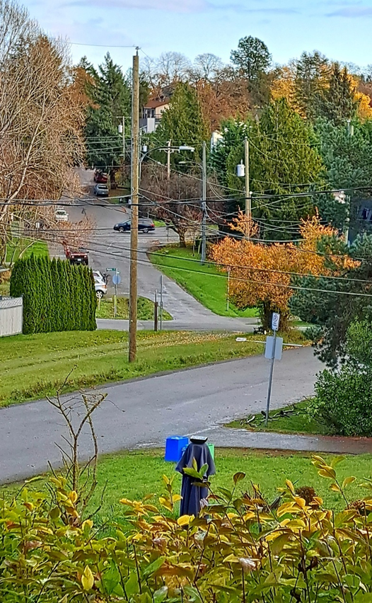
Red star above – 1544 Christmas Avenue lowest point in the area where water pools. Shelbourne Street Is above with the black car. Across Shelbourne Street is Christmas Avenue East with the steep slope. If a development proceeds, future condo owners will have problems with flooding and insuring their properties. High earthquake risk.
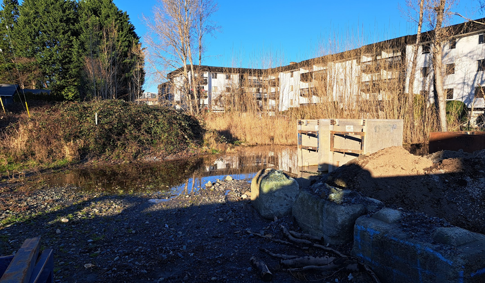
Pond at 1544 Christmas Avenue on 17 January 2026

Leave a comment